
Trace a Macomb Township Street
For a Macomb Township address, begin with the property record and preserve the links between each record rather than relying on a name alone. The assessor record can tie a situs address to a parcel, owner, values, sales, legal description, and property context. The parcel number is especially useful because street wording and mailing details can change. After the parcel is identified, the county map can place it among nearby polygons and the recorder can connect it to recorded instruments. A deed confirms a recorded party and transaction, not every person who may be present at an address. The individual voter tool is also a confirmation route, not a public street-wide display.
- Search the address in BS&A Online Public Records and copy the situs address, parcel or reference number, owner, legal description, sales details, and any PRE context shown.
- Open the same location through Macomb County GIS. Turn on the parcel and address-points layers, then note the associated parcel polygon before comparing adjacent records.
- Use the parcel ID or legal description in the Macomb County Register of Deeds search to locate recorded deeds, mortgages, liens, plats, or related instruments.
- When an individual registration needs confirmation, use the Michigan Voter Information Center with the required identity refinements. It cannot generate a public list for an entire street.
- For an older address, compare library directory material and maps with the parcel description. Keep the publication year separate from a current ownership record.
Note: Repeated address queries and map browsing are documented methods; neither source promises a complete one-click export for a whole street.
Macomb Township Street Directory Fields
Macomb Township Assessing maintains roughly 34,500 real parcels and 1,000 personal-property accounts. Its public BS&A system is available at all hours, while public inspection at the township is available during the office schedule. The system warns that information may not be complete or accurate, so copy the record date with the result. Address, name, and parcel searches reach different service areas. An address can be used across property, tax, building, utility-billing, and miscellaneous-receivable routes, but an address result remains record-specific.
| BS&A field or service | Input | Required | Macomb Township use |
|---|---|---|---|
| Address | Text | No, selected mode | Situs or address-keyed search |
| Name | Text | No, selected mode | Owner or name route; partial-match behavior was not documented |
| Parcel Number | Text | No, selected mode | Stable parcel identifier |
| Property and Tax | Service cards | No | Owner, situs, values, sales, legal description, and assessment context |
| Building Department | Record number or service | No | Building or permit route |
| Utility Billing and Receivables | Account, customer ID, or invoice | No | Address-linked service areas with privacy limits |
Use the parcel field when an address returns more than one possible result or when a road name has an older form. A name search may show several parcels. The online service can assess a small convenience charge for some functions, and the township gives a three to seven business day production estimate for requests that need records beyond the ordinary public display. For a nonexempt township record, a narrow request under the Michigan FOIA is the documented fallback.
Map a Macomb Township Street
The township's map collection and the county GIS hub serve different parts of a street search. Township map links include zoning, voting-precinct lookup, development activity, parks, drains, street and fire maps, and planning material. The county system supplies Parcel Explorer and open-data routes. The county user guide says a result is associated with one tax parcel and that the address-points layer must be selected to show address-linked map results.
Zoom to the road, activate parcels and address points, select a polygon, and write down its parcel or reference ID. Then return to BS&A for the associated property record. Zoning, development, park, drain, and road layers provide geographic context, but they do not identify a household. The public materials do not document a reliable buffer or automatic whole-block control, so a street directory search should not claim that the map creates a street roster. GIS questions go to the county office at 586-469-5285 or gis.questions@macombgov.org.
Macomb Township Street Name Variants
Macomb Township uses numbered mile roads and local aliases. Those alternate forms can be the missing key when a deed, newspaper, directory, or map does not use the modern wording. The township history identifies 20 Mile as M-59, Hall, or Rosso; 21 Mile as Shoemaker; 22 Mile as Waldenburg; 23 Mile as Romeo Plank or Whiskey to the east and Coldwater to the west; 24 Mile as French; 25 Mile as Arnold; and 26 Mile as Marine City Highway. Search each likely road form, then use the parcel and legal description to decide whether two references describe the same place.
No official township street-renumbering year, large renaming project, or annexation map that changed present addresses was located. That gap matters. Do not assign a new street number to an old record by guesswork. The legal description, subdivision or lot, and parcel history are steadier bridges than street text alone. The county GIS office is the documented point of contact for addressing and parcel geography.
Follow Macomb Township Street Deeds
The Register of Deeds search options describe a free basic grantor, grantee, or name search. The advanced route supports address, legal description, parcel ID, and names, along with copy and certification requests. Begin with the present owner as a grantee, inspect the recorded instrument, identify the prior grantor, and repeat while testing the legal description against the parcel. This method is stronger than an address-only search when a subdivision, spelling variation, or other address change interrupts the street trail.
Use the document number, liber and page where available, instrument type, recording date, parties, parcel, and legal description as separate facts. The county does not publish a verified first year for the online index and warns that records may be in progress or not fully indexed. Older coverage must be confirmed with the recorder rather than assumed. In-person public terminals at 120 N. Main Street in Mount Clemens are free to view indexes. Staff searches cost $5 per search plus $1 per page, and the office recommends appointments. Mail requests use the county real-estate record-search form and need enough party, address, or legal-description detail to identify the record.
The recorder search-options screen illustrates the county's basic and advanced search paths.
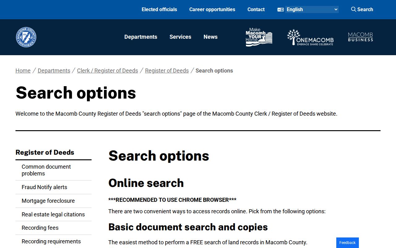
The screen supports a recorded-instrument workflow, while the parcel and legal description keep a street search tied to the right property.
Macomb Township Street Records Compared
Each address-keyed source answers a narrow question. The assessor records a parcel relationship. GIS supplies the parcel's map setting. The recorder shows recorded instruments, and the voter system confirms an individual registration under its own rules. A historical directory can attach a name or business to an address in a stated publication year. Read the layers together, not as interchangeable proof of current occupancy.
| Address-keyed source | Custodian | What it can establish | Access channel |
|---|---|---|---|
| Property and tax record | Macomb Township Assessing / BS&A | Owner, situs, mailing address, parcel, values, sales, PRE, improvements | Public online search, public inspection, inquiry, or FOIA where applicable |
| Parcel and map layers | Macomb County GIS / township maps | Parcel polygon, address-point context, zoning, precinct, development and public layers | Public map, open-data route, or GIS contact |
| Recorded instruments | Macomb County Register of Deeds | Parties, instrument, date, legal description, document reference | Free basic search, advanced subscription, terminal, staff search, or mail request |
| Voter registration | Michigan Secretary of State / County Elections | Individual status and local-clerk information; limited record fields by lawful request | MVIC, county request form, or state QVF FOIA form |
| Building record | Township building route / BS&A | Project address and documented permit context where a record is available | Building service route or township request; historic online coverage not located |
| Historical directory | Mount Clemens Public Library | Publication-year occupant or business address evidence | Library master index, scans, research request, and local-history material |
Note: An owner mailing address, a directory entry, or a voter match has a different purpose and none establishes every person at a parcel.
Macomb Township Street Sales
Property sales can help place a recorded change along a road, but they should be checked against the deed index. The BS&A property-sale form offers filters for sale date and price, grantor, grantee, class, floor area, year built, bedrooms, bathrooms, and neighborhood. A ZIP field was not visible in the inspected form. The sale search is useful for narrowing a transaction question, not for making a street-wide resident list.
The BS&A property-sale search shows the available sale and property filters for the township.
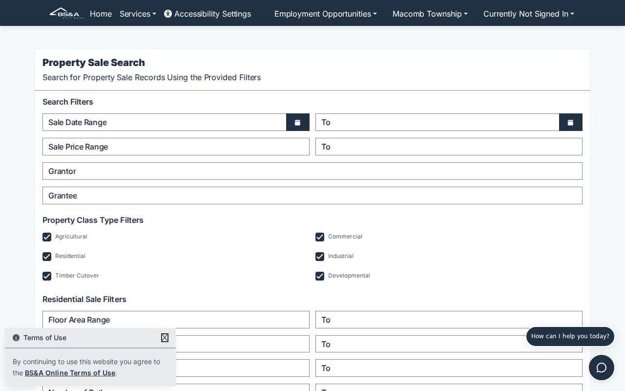
Pair any filtered sale result with the parcel number and recorded deed before treating it as part of a Macomb Township street history.
Macomb Township Street Voter Limits
Michigan's public voter interface is an individual lookup. The name route requires first name, last name, birth month, birth year, and a five-digit ZIP. The system also has a license route, plus an early-voting address route that asks for street address, city, state, and ZIP. A result helps a voter confirm registration status and locate clerk or early-voting information. It does not display ballot selections, and Michigan does not register voters by party affiliation.
Voter-registration records are public under Michigan law, but driver's-license or state-ID numbers, full birth month and day, telephone, email, and protected information are withheld. A County Elections request can seek certain lists by district or jurisdiction and has a $10 minimum based on staff time. The state QVF FOIA form supports statewide, county, jurisdiction, district, ward, or precinct scope, not a general ZIP or street boundary. Do not infer a move from a no-match or turn a limited voter record into a street roster.
Macomb Township Street Permit Trail
Building records can date a visible change at an address. The documented sources describe project address, subdivision or lot, owner, applicant, contractor, description, valuation, fees, and construction choices on permit material. BS&A includes a Building Department record-number route. The township assessor also maintains permit-based measurements and inspects new construction. Those records may help explain an addition, demolition, pool, roof, foundation, occupancy certificate, or plot-plan event when a record is publicly available.
Historic public search coverage for permits and code matters was not located. A permit or complaint is an administrative record, not proof that anyone violated an ordinance. Ask the township for the relevant date and address, and use the parcel and legal description to prevent an address mix-up.
Historic Macomb Township Street Entries
For older street evidence, the Mount Clemens City Directory Master Index has a published 1896 to 1966 span, although continuous coverage has not been confirmed. Search the street or address, read the person or business entry, and compare nearby publication years. The sources identify specific directory runs from 1899 through 1925 and a Farm Journal Rural Directory of Macomb County run from 1916 to 1921. A Mount Clemens directory is city-centered, so a township address may appear in a rural volume or not appear at all.
A criss-cross directory reverses the ordinary name-first arrangement by organizing entries by address. It is historical evidence, not a current street list. Road aliases are important here because a period directory may use a different mile-road name. Detailed library holdings, publisher runs, and research-request options belong with the Macomb Township city directories; use the historical entry only after checking the correct jurisdiction and year.
Verify a Macomb Township Street
Keep a short evidence log for each address: search date, street form used, parcel number, situs address, legal description, source URL, document reference, and publication year where relevant. Compare identity fields across sources before joining them. For an older result, try the road alias, then the current form, and rely on the parcel or legal description when the textual address is uncertain. The terms below prevent a street directory search from blending distinct facts.
- Parcel
- A tax parcel is the unit of property used by the assessor and GIS. Its identifier is often the most stable link between a map, property record, and recorded instrument.
- Situs address
- The situs is the physical location of the parcel. It differs from an owner's mailing address, which is where notices are sent.
- Plat
- A plat is a recorded map or plan that can tie a parcel to a subdivision, lot, block, or legal description.
- Criss-cross directory
- An address-arranged historical directory used to identify a publication-year occupant or business at a listed location.
Macomb Township Street Directory Limits
A Macomb Township street directory cannot reveal every private connection to an address. The assessor shows ownership and tax context, not a complete household. Recorded deeds show parties to instruments, not all occupants. Public map layers do not create a social list. Utility customer details, driver records, protected voter information, sealed court participants, and unindexed material have their own restrictions. Michigan's Address Confidentiality Program provides substitute-address and mail-forwarding protections for eligible participants, and protected information must not be reverse-engineered from public tools.
When a record looks incomplete, contact the custodian instead of filling gaps with an assumption. The assessor accepts inquiries by email at assessor@macomb-mi.gov or by phone at 586-992-0710, extension 2. The Register of Deeds lists its search, terminal, staff, and mail channels. A narrow request is more likely to be usable when it includes the address, parcel, date range, and document type sought.